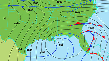
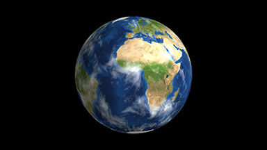
WEATHER FORECAST MAP OF SOUTH WEST USA - STOCK VIDEO

Animation of atmospheric pressure and weather fronts.
Duration: 27.87 seconds

 © synthetick

KEYWORDS:  weather, map, meteorology, isobar, satellite, view, heat, hot, cartography, media, radar, thermal, change, storm, high, climate, temperature, background, warning, symbol, television, cold, front, warm, low, pressure, rain, wind, video, green, blue, news, forecast, atmospheric, prediction, contour, barometric, usa, united states, north, america, new, mexico, california, arizona, texas, south, west, western
GET THE UN‑WATERMARKED HIGH QUALITY VERSION:
Download from Pond5, Adobe Stock or Shutterstock
CART SALES Cart sales are via Pond5 and are the best value for occasional purchases. An additional 20% referral discount will be applied at the checkout. Prices are in USD.
SUBSCRIPTION SALES Download this video from either: Adobe Stock Shutterstock

Subscriptions are the best value if you buy videos regularly. Get bulk videos for a flat low cost monthly fee. Various plans are available. 

LICENSING See terms of use here
Duration:  27.87 seconds
Description:  Animated weather forecast map of south west United States of America with isobars, cold and warm fronts, high and low pressure systems.
Duration:  27.87 seconds
Related videos: 
Keywords:  weather, map, meteorology, isobar, satellite, view, heat, hot, cartography, media, radar, thermal, change, storm, high, climate, temperature, background, warning, symbol, television, cold, front, warm, low, pressure, rain, wind, video, green, blue, news, forecast, atmospheric, prediction, contour, barometric, usa, united states, north, america, new, mexico, california, arizona, texas, south, west, western
  © 2022 synthetick.com